November 11, 2007, 12 vessels were wrecked in a severe storm
in the Kerch Strait dividing the Black and Azov Seas.
The Russian oil tanker Volgoneft-139 was broken apart spilling
at least two thousand tonnes of fuel oil. The tanker’s the
stern-part was towed to Port Kavkaz. Fuel oil remaining in the
sunken bow part of the tanker was pumped out. The lift up
of the tanker wreck was postponed till springtime. However,
later official reports stated that the sunken part of the
Volgoneft-139 was of no environmental hazard and it was decided
to leave it where it was, at the bottom of the Kerch Strait.
The region of the Kerch Strait has long been in the focus
of operational satellite monitoring of sea state and pollution
conducted by the Space Radar
Laboratory of the Space Research Institute of Russian
Academy of Sciences (IKI RAS, head of Laboratory
Olga Lavrova) jointly with
SRC “Planeta”. The observations hold that, starting mid-June
2008, oil pollution of the sea surface in the area of the tanker
catastrophe has persisted. This is explained by seasonal water
heating and consequent rise of the sunken fuel to the surface.
The fragments of Envisat ASAR images presented below are obtained
during summer 2008 and evidence the fact of resumed oil pollution.
The images were obtained under the European Space Agency project
AOBE.2775.
Any use of the materials presented on this
page requires permission from the developers and obligatory reference
to this site.
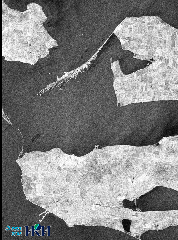
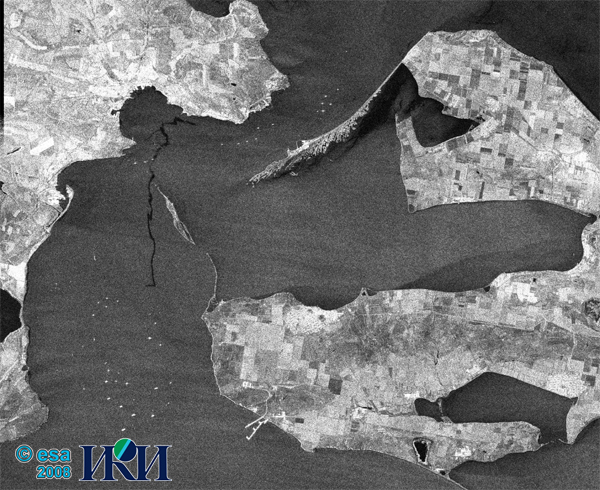
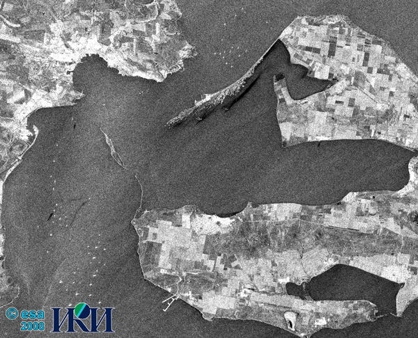
A fragment of Envisat ASAR Alternating Polarization Mode image
obtained 16 June, 2008 19:30:50 UTC. Spatial resolution of the
original image is 12.5 m; VV-polarization. Obtained under weak SW winds,
the image distinctly shows a slick stretching to the Tuzla Island.
The length of the slick inside the image frame is 2.3 km. At the Tuzla
Dam, a 4.6-km long plume of pollution is easily detected.
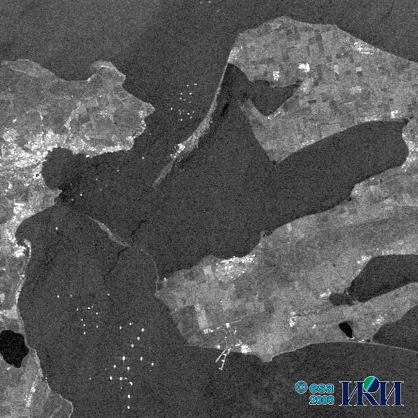
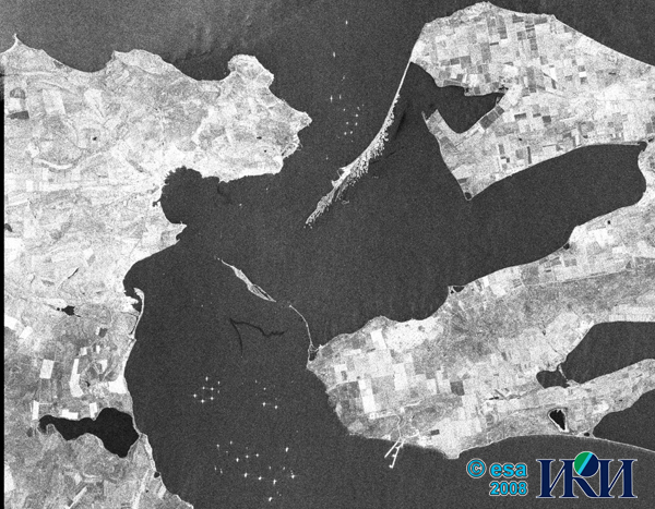
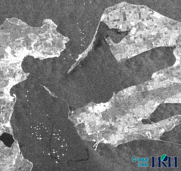
A fragment of Envisat ASAR Wide Swath image obtained 17 June, 2008
at 07:40:09 UTC. Spatial resolution of the original image is 75 m;
VV-polarization. The image was obtained under wind speeds of up to
7 m/s with W to S directions. Approximate coordinates of the pollution
source are 45.218°N, 36.533°E. The pollution tail of 9 km stretches
to Tuzla Spit.
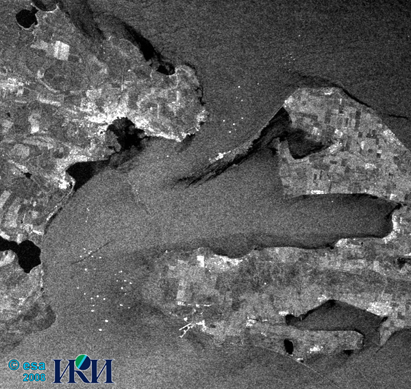
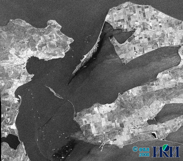
A fragment of Envisat ASAR Wide Swath image obtained 26 June, 2008
at 19:15:59 UTC. Spatial resolution of the original image is 75 m;
VV-polarization. The image was obtained under weak N wind. The 8.3-km
long pollution tail is spreading SW towards Crimean Peninsula.
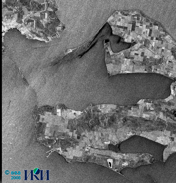
A fragment of Envisat ASAR Wide Swath image obtained 6 July, 2008
at 07:42:57 UTC. Spatial resolution of the original image is 75 m;
VV-polarization. The image was obtained under SSW wind; wind speed
5-7 m/s. The tail stretches to Tuzla Spit, passes between Tuzla Spit
and Tuzla Dam and heads towards Chushka Spit. Total length of the tail
is nearly 12 km.
A fragment of Envisat ASAR Image Mode image obtained 18 July, 2008
at 19:25:09 UTC. Spatial resolution of the original image is 12.5 m;
VV-polarization. The image was obtained under S winds; wind speed 6-8 m/s.
The tail stretches northward, nearly reaching the shoreline of Kerch
Peninsula. Total length of the slick exceeds 20 km. It is difficult
to define the reasons of such a great extension of the pollution tail,
but it starts directly from the point where the bow part of the sunken
Volgoneft-139 tanker lies.
A fragment of Envisat ASAR Image Mode image obtained 19 July, 2008
at 07:34:43 UTC. Spatial resolution of the original image is 12.5 m;
VV-polarization. The image was obtained under SW winds; wind speed
4-5 m/s. At the beginning, the tail stretches in NE direction and then
turns eastward, continuing nearly parallel to Tuzla Spit and Dam.
Total length of the slick exceeds 9 km. The source of the tail coincides
with the location of the sunken bow part of the Volgoneft-139.
A fragment of Envisat ASAR Image Mode image obtained 22 July, 2008
at 07:40:25 UTC. Spatial resolution of the original image is 12.5 m;
VV-polarization. The image was obtained under NE winds; wind speed
4-7 m/s. The tail stretches SW. Total length of the slick is about
6 km. The source of the tail coincides with the location of the sunken
bow part of the Volgoneft-139.
A fragment of Envisat ASAR Image Mode image obtained 31 July, 2008
at 19:16:33 UTC. Spatial resolution of the original image is 12.5 m;
VV-polarization. The image was obtained under N winds; wind speed 5 m/s.
The tail stretches southward. Total length of the slick is over 4 km.
The source of the tail coincides with the location of the sunken bow
part of the Volgoneft-139.
A fragment of Envisat ASAR Image Mode image obtained 3 August, 2008
at 19:22:19 UTC. Spatial resolution of the original image is 12.5 m;
VV-polarization. The image was obtained under NE winds; wind speed
up to 8 m/s. The tail of 4 km in length spreads SW. Some other slicks
also can be detected in the image. Presumably, they are due to fresh
spills from ships. The slicks are located at 45.187°N, 34.479°E and
45.285°N, 36.488°E; their areas are 230 and 107 m2, respectively.
Fragment of Envisat ASAR Wide Swath image obtained 7 August, 2008
at 07:37:14 UTC. Spatial resolution of the original image is 75 m;
VV-polarization. The image was obtained under NE wind; wind speed
6-7 m/s. Pollution tail spreads SE; its length is 14 km.
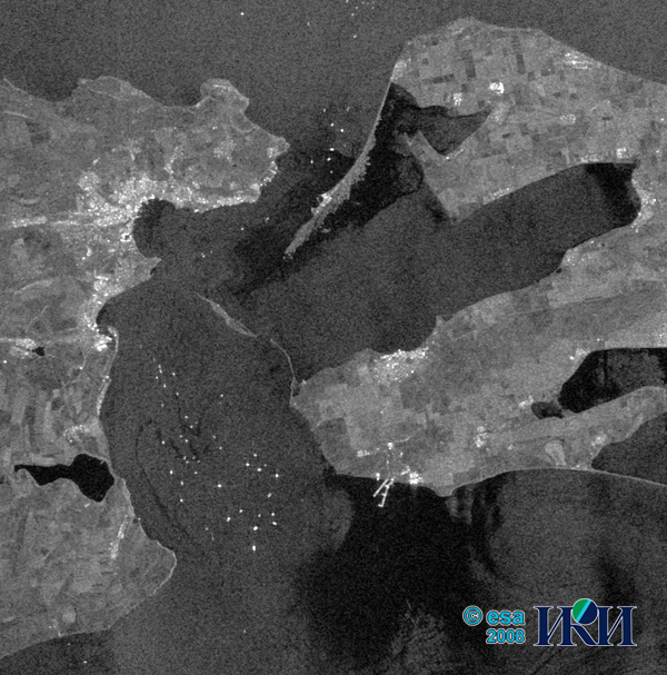
Fragment of Envisat ASAR Wide Swath image obtained 10 August, 2008
at 07:42:53 UTC. Spatial resolution of the original image is 75 m;
VV-polarization. The image was obtained under unstable N/E wind;
wind speed up to 4 m/s. Multiple pollution spills can be seen at the
anchor site including the location of the tanker’s wreck.
According to the Press Service of the Ministry of Transportation
of Russia, on 12 August, 2008 the bow part of the Volgoneft-139 was
emptied, and on 13 August, the wreck was towed to Port Kavkaz by
tow-boats "Zaliv" and "Kapitan Zadorozhny" assisted by research vessel
"Impulse".
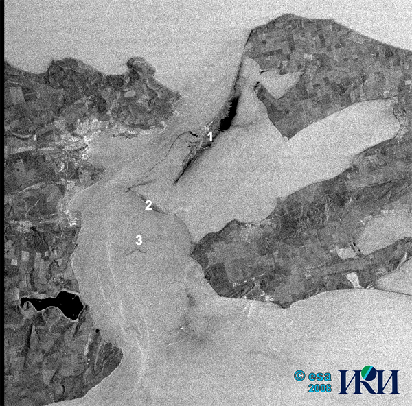
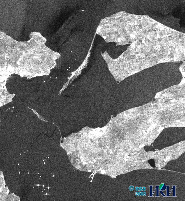
A fragment of Envisat ASAR Alternating Polarization Mode image
obtained 16 August, 2008 at 07:54:37 UTC. Spatial resolution of the
original image is 12.5 m; VV-polarization. The image was obtained
under NE winds; wind speed up to 6 m/s. A long pollution tail spreads
from Port Kavkaz (1) to the western end of Tuzla Spit (2). Possibly, it is
the consequence of the tanker’s wreck transportation. Also, some
residual pollution slicks with total length of about 3 km can be
detected at the wreck site (3).
© ESA, 2008 - Envisat ASAR images.
© IKI RAS, 2008 - ASAR images interpretation.
|
|
©
IKI RAS, 2008
|
|