Man's mind and spirit grow with the space in which they are allowed to operate. - Krafft A. Ehricke
Callisto [kah-LISS-toe] is the second largest moon of Jupiter, the third largest in the solar system, and is about the same size as Mercury. It orbits just beyond Jupiter's main radiation belt. Callisto is the most heavily cratered satellite in the solar system. Its crust is very ancient and dates back 4 billion years, just shortly after the solar system was formed.
Callisto lacks any large mountains. This is probably due to the icy nature of its surface. Impact craters and associated concentric rings are about the only features to be found on Callisto. The largest craters have been erased by the flow of the icy crust over geologic time. Two enormous concentric ring, impact basins are found on Callisto. The largest impact basin is Valhalla. It has a bright central region that is 600 kilometers in diameter, and its rings extend to 3000 kilometers in diameter. The second impact basin is Asgard. It measures about 1600 kilometers in diameter.
Callisto has the lowest density (1.86 gm/cm3) of the Galilean satellites. The moon is probably made of a large rocky core surrounded by water and ice, giving it a dark color. It is composed of approximately equal proportions of ice-water and rock. Meteorites have punctured holes in the crust, causing water to spread over the surface and forming bright rays and rings around the crater. Callisto has no known atmosphere.
| Views of Callisto |
|---|
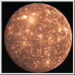
Callisto
This image shows the heavily cratered surface of Callisto. It was taken
by Voyager 2 on July 7, 1979.
An enormous impact basin with concentric rings is located near the top and
slightly left of center.
(Credit: Calvin J. Hamilton)
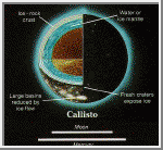 Model of Callisto's Interior
This is an illustration Callisto's interior. Callisto has the
lowest density (1.86 gm/cm^3) of all the Galilean satellites.
Its interior is probably similar to Ganymede except the inner
rocky core is smaller, and this core is surrounded by a large
icy mantle.
(Courtesy NASA/JPL)
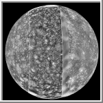
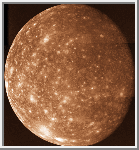 High-Resolution Image of Callisto
This high-resolution image of Callisto shows its heavily cratered
surface. The impact basin, Valhalla, is located towards the bottom-left
of the image.
(Credit: Calvin J. Hamilton)
 Callisto's Valhalla Region
This close up of Callisto shows the heavily cratered surface and
the prominent ring structure known as Valhalla. It was acquired by
Voyager 1 on March 6, 1979.
Valhalla's bright central area is about 300 kilometers across with sets
of concentric ridges extending out to 1,500 kilometers from the center.
(Credit: Calvin J. Hamilton)
 Gipul Catena
This image of an chain of craters on Callisto is 620 kilometers long.
The largest crater is 40 kilometers across. This is the longest of 12
or so such chains on Callisto. The chain probably formed from the
collision of a comet that was tidally disrupted during close
passage of Jupiter, such as the comet
Shoemaker-Levy 9.
(Credit: Calvin J. Hamilton)
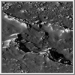
 Callisto's Valhalla Impact Structure
A portion of the central zone of the large impact structure
Valhalla on Callisto was imaged by the Galileo
spacecraft on November 4, 1996. The area shown here is centered at 16
degrees north, 55 degrees west and is about seven miles (11 kilometers)
across. This is the highest resolution picture ever taken of Callisto
and shows features as small as 200 feet (60 meters) across. The formation
of Valhalla occurred early in Callisto's history; however, the central zone
shown here is probably younger than Valhalla's surrounding structure.
This newly acquired picture shows some small craters, although they
have been softened or modified by downslope movement of debris,
revealing bright ice-rich surfaces. In contrast to other areas on
Callisto, most of the very smallest craters appear to have been
completely obliterated.
(Courtesy NASA/JPL)
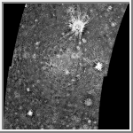 Asgard Impact Structure on Callisto
This four-frame mosaic shows the ancient impact structure Asgard on
Callisto. This image is centered at 30 degrees north,
142 degrees west. The Asgard structure is approximately 1700 km across
(1,056 mi) and consists of a bright central zone surrounded by
discontinuous rings. The rings are tectonic features with scarps near
the central zone and troughs at the outer margin. Several large impacts
have smashed into Callisto after the formation of Asgard. The very
young, bright-rayed crater Burr is located on the northern part of
Asgard. This mosaic has been projected to show a uniform scale between
the four mosiacked images. The image was processed by Deutsche
Forschungsanstalt fuer Luft-und Raumfahrt e.V., Berlin, Germany.
This image was taken on November 4, 1996, at a distance of 111,891
kilometers (69,070 miles) by the Galileo spacecraft during its third
orbit around Jupiter.
(Courtesy NASA/JPL)
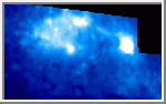 Callisto Asgard Region as Viewed by NIMS
This view of Callisto's Asgard multi-ring structure was taken by the Near
Infrared Mapping Spectrometer (NIMS) 90 minutes before closest approach.
The false color image shows surface compositional differences, white=more
ice, blue=less ice. The large bright/white area is the palimpsest or
center of Asgard. The smaller bright area is Tornasuk, a crater with a
diameter of about 70 km.
The infrared spectrum shows that Tornasuk exhibits a greater abundance of
water ice compared with the surrounding region. This may be due to impact
excavation revealing a more ice-rich subsurface and suggesting that the
darker material is a relatively thin surface covering. This covering
could be either impact debris material or a lag deposit of existing
material from which the ice has evaporated away.
(Courtesy NASA/JPL)
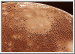
 A Chain of Impact Craters on Callisto
A portion of a chain of impact craters on Callisto is
seen in this image taken by the Galileo spacecraft on November 4, 1996.
This crater chain on Callisto is believed to result from the impact of
a split object, similar to the fragments of Comet
Shoemaker-Levy 9
which smashed into Jupiter's atmosphere in July of 1994. This high-resolution
view is of Callisto's northern
hemisphere at 35 degrees north, 46 degrees west, and covers an area of
about eight miles (13 kilometers) across. The smallest visible crater
is about 140 yards (130 meters) across. The image was taken at a range
of 974 miles (1,567 kilometers).
On a global scale, Callisto is heavily cratered, indicating the great
age of its surface. At the scale of this image, it was anticipated that
the surface would be heavily cratered as well; however, there is a
surprising lack of small craters, suggesting that one or more processes
have obliterated these and other small-scale features. For example,
downslope movement of ice-rich debris could bury small craters. The
bright slopes visible in this picture represent places where downslope
movement has taken place, exposing fresh ice surfaces.
(Courtesy NASA/JPL)
 View of Callisto from Voyager and Galileo
This mosaic was prepared from images obtained by three spacecraft:
Voyager 1 (left side), Galileo (middle), and Voyager 2 (right side).
The Voyager data were taken in 1979 but left a "gap" centered
at longitude 290 degrees in the trailing hemisphere of Callisto.
The Galileo Solid-State Imaging system photographed this area
on its second orbit around Jupiter on 9 September, 1996 Universal Time.
The resolution of the Galileo data is 4.3 kilometers/pixel (2.7 miles),
meaning that the smallest visible feature is about 12 kilometers (7 miles)
across. North is to the top of the picture.
Features of interest in the new Galileo data include a dark, smooth area
in the northern latitudes (upper third) which appears to mantle older terrain.
This could be dark ejecta from a small impact crater. Also visible is
a fresh, sharp-rimmed crater some 90 km (56 miles) across named Igaluk
(center left third of picture), and a bright zone in the south polar area
(bottom of image) which could be an impact scar.
(Courtesy NASA/JPL)
Copyright © 1997 by Calvin J. Hamilton. All rights reserved.