Triton [TRY-tun] is the largest moon of Neptune, with a diameter of 2,700 kilometers (1,680 miles). It was discovered by William Lassell, a British astronomer, in 1846 scarcely a month after Neptune was discovered. Triton is colder than any other measured object in the Solar System with a surface temperature of -235° C (-391° F). It has an extremely thin atmosphere. Nitrogen ice particles might form thin clouds a few kilometers above the surface. The atmospheric pressure at Triton's surface is about 14 microbars, 1/70,000th the surface pressure on Earth.
Triton is the only large satellite in the solar system to circle a planet in a retrograde direction -- in a direction opposite to the rotation of the planet. It also has a density of about 2.066 grams per cubic centimeter (the density of water is 1.0 gram per cubic centimeter). This means Triton contains more rock in its interior than the icy satellites of Saturn and Uranus do. The relatively high density and the retrograde orbit has led some scientists to suggest that Triton may have been captured by Neptune as it traveled through space several billion years ago. If that is the case, tidal heating could have melted Triton in its originally eccentric orbit, and the satellite might even have been liquid for as long as one billion years after its capture by Neptune.
Triton is scarred by enormous cracks. Voyager 2 images showed active geyser-like eruptions spewing nitrogen gas and dark dust particles several kilometers into the atmosphere.
| Animations of Triton |
|---|
| Views of Triton |
|---|
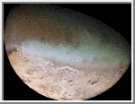
Triton
Voyager 2
obtained this color image of Neptune's
large satellite Triton during its close flyby on Aug. 25, 1989.
The large south polar cap at the bottom of the image is
highly reflective and slightly pink in color; it might consist of a
slowly evaporating layer of nitrogen ice deposited during the
previous winter. From the ragged edge of the polar cap northward,
the satellite's face is generally darker and redder in color.
This coloring may be produced by the action of ultraviolet light
and magnetospheric radiation
upon methane in the atmosphere and
surface. Running across this darker region, approximately
parallel to the edge of the polar cap, is a band of brighter
white material that is almost bluish in color. The underlying
topography in this bright band is similar; however, to that in the
darker, redder regions surrounding it.
(Courtesy NASA/JPL)
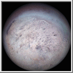 Triton
This picture is a global orthographic view of Triton centered at
-40° latitude and 0° longitude. It was created from
images obtained by the Voyager 2 spacecraft.
(Courtesy A. Tayfun Oner)
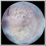
 Simple Cylindrical Map of Triton
This image is a simple cylindrical map of Triton. The map covers the
entire surface of Triton; however, because of the lack of data above 40
degrees north, those regions were rendered black. The map is centered at
0 degrees longitude and 1 pixel equals 3.5 kilometers at the equator
(for the TIFF and JPEG images). The color was taken from the green,
violet and UV filters of the Voyager 2 cameras and are not necessarily
correct.
(Courtesy A. Tayfun Oner)
 Southern Hemisphere of Triton
This image is a polar stereographic projection of the southern
hemisphere of Triton. Zero degrees longitude is located at the top.
(Courtesy A. Tayfun Oner)
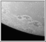
 South Pole of Triton
This high resolution image of Triton was obtained by Voyager 2
on August 25, 1989. It shows the moon's south polar cap. One
of the unusual aspect of this image is the dark streaks in the
images. Perhaps they were made by geyser-like eruptions of
nitrogen. The geyser eruptions could have carried darker
materials from the crust. The light regions probably consist
of layers of nitrogen.
(Credit: Calvin J. Hamilton)
 Plain of Ice
This view of Triton shows a plain of ice. It was probably formed by
eruptions of water or a water-ammonia slurry. It seems to fill the
remains of an ancient impact basin.
(Credit: Calvin J. Hamilton)
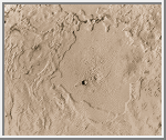
 Triton in 3D
This is a computer-generated perspective rendering of one of
the caldera-like
depressions on Triton, as it would appear if
viewed from the northeast. The image was obtained
Aug. 24, 1989, when the Voyager spacecraft was about
181,800 kilometers
(112,900 miles) from Triton.
The caldera floor shown in this image is approximately
200 kilometers (120 miles) in
diameter. It is extremely flat and probably was formed by the
volcanic eruption of ice lavas of very low viscosity. The
bench visible in the foreground may be a remnant of earlier
flooding to a level about 200 meters (600 feet) higher than
the present caldera floor.
(Courtesy NASA/JPL)
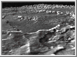
 Surface of Triton
This is one of the most detailed views of the surface
of Triton taken by Voyager 2 on its flyby of the large satellite of
Neptune early in the morning of August 25, 1989. The picture was taken from a distance
of 40,000 kilometers (25,000 miles), the frame is about 220 kilometers (140
miles) across and shows details as small as 750 meters (0.5 miles). Most
of the area is covered by a peculiar ladnscape of roughly circular
depressions separated by rugged ridges. This type of terrain, which covers
large tracts of Triton's northern hemisphere, is unlike anything seen
elsewhere in the solar system. The depressions are probably not impact
craters: They are too similar in size and too regularly spaced. Their
origin is still unknown, but may involve local melting and collapse of the
icy surface. A conspicuous set of grooves and ridges cuts across the
landscape, indicating fracturing and deformation of Triton's surface. The
rarity of impact craters suggests a young surface by solarsystem
standards, probably less than a few billion years old.
(Courtesy NASA/JPL)
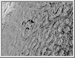
 Dark Areas on Triton
Voyager 2 acquired this black and white image of
Triton during the night of August 24-25, 1989.
Triton's limb cuts obliquely across the middle of the image. The field of
view is about 1,000 km (600 miles) across. Three irregular dark areas,
surrounded by brighter material, dominate the image. Low-lying material
with intermediate albedo occupies the central area, and fresh craters
occur along the right margin. Sub-parallel alignment of linear patches of
dark material shown in the lower and left part of the image suggests that
the patches are structurally controlled.
(Courtesy NASA/JPL)
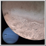 Montage of Neptune and Triton
This computer generated montage shows Neptune as it
would appear from a spacecraft approaching Triton.
The wind- and sublimation-eroded south
polar cap of Triton is shown at the bottom of the Triton image, a
cryovolcanic terrain at the upper right, and the enigmatic cantaloupe
terrain at the upper left. Triton's surface is mostly covered by nitrogen
frost mixed with traces of condensed methane, carbon dioxide, and carbon
monoxide. The tenuous atmosphere of Triton, though only about one-hundredth
of one percent of Earth's atmospheric density at the surface, is
thick enough to produce wind-deposited streaks of dark and bright
materials of unknown composition in the south polar cap region. The
southern polar cap was sublimating at the time of the Voyager 2 flyby, as
indicated by the irregular and eroded appearance of the edge of the cap.
The polar frosts were sublimating because Triton's orbital and rotational
motion causes the sun to shine directly on the polar cap for a period of
several decades during Neptune's and Triton's long austral summer. Though
the polar cap was undergoing heat death, surface temperatures still were
only about 38 K (-391 degrees Farenheit).
(Courtesy NASA/JPL)
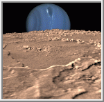 Neptune on Triton's Horizon
Composite view showing Neptune on Triton's horizon.
Neptune's south pole is to the left; clearly visible in the planets'
southern hemisphere is a Great Dark Spot, a large anticyclonic storm
system located about 20 degrees South. The foreground is a computer
generated view of Triton's maria as they would appear from a point
approximately 45 km above the surface. The terraces visible in this image
indicate multiple episodes of 'cryovolcanic' flooding. This three-dimensional
view was created from a Voyager image by using a two-dimensional
photoclinometric model. Relief has been exaggerated roughly
30-fold, the actual range of the relief is about 1 km. Would Neptune
appear to be rising or setting? Neither, due to the motion of Triton
relative to Neptune, it would appear to move laterally along the horizon,
eventually rising and setting at high latitudes.
(Courtesy NASA/JPL)

 Neptune
 Proteus
 Nereid