My view of our planet was a glimpse of divinity.
-Edgar Mitchell, USA
| Introduction |
|---|
From the perspective we get on Earth, our planet appears to be big and sturdy with an endless ocean of air. From space, astronauts often get the impression that the Earth is small with a thin, fragile layer of atmosphere. For a space traveler, the distinguishing Earth features are the blue waters, brown and green land masses and white clouds set against a black background.
Many dream of traveling in space and viewing the wonders of the universe. In reality all of us are space travelers. Our spaceship is the planet Earth, traveling at the speed of 108,000 kilometers (67,000 miles) an hour.
Earth is the 3rd planet from the Sun at a distance of about 150 million kilometers (93.2 million miles). It takes 365.256 days for the Earth to travel around the Sun and 23.9345 hours for the Earth rotate a complete revolution. It has a diameter of 12,756 kilometers (7,973 miles), only a few hundred kilometers larger than that of Venus. Our atmosphere is composed of 78 percent nitrogen, 21 percent oxygen and 1 percent other constituents.
Earth is the only planet in the solar system known to harbor life. Our planet's rapid spin and molten nickel-iron core give rise to an extensive magnetic field, which, along with the atmosphere, shields us from nearly all of the harmful radiation coming from the Sun and other stars. Earth's atmosphere protects us from meteors, most of which burn up before they can strike the surface.
From our journeys into space, we have learned much about our home planet. The first American satellite, Explorer 1, discovered an intense radiation zone, now called the Van Allen radiation belts. This layer is formed from rapidly moving charged particles that are trapped by the Earth's magnetic field in a doughnut-shaped region surrounding the equator. Other findings from satellites show that our planet's magnetic field is distorted into a tear-drop shape by the solar wind. We also now know that our wispy upper atmosphere, once believed calm and uneventful, seethes with activity -- swelling by day and contracting by night. Affected by changes in solar activity, the upper atmosphere contributes to weather and climate on Earth.
Besides affecting Earth's weather, solar activity gives rise to a dramatic visual phenomenon in our atmosphere. When charged particles from the solar wind become trapped in Earth's magnetic field, they collide with air molecules above our planet's magnetic poles. These air molecules then begin to glow and are known as the auroras or the northern and southern lights.
| Animations of Earth |
|---|
| Views of Earth |
|---|
The following set of images show some of the wonders of our planet, the Earth.
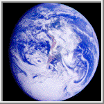
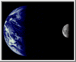
South America
This color image of the Earth was obtained by
Galileo at about
6:10 a.m. Pacific Standard Time on Dec. 11, 1990, when the
spacecraft was about 1.3 million miles from the planet. Galileo was
making the first of two Earth flybys on its way to Jupiter.
South America is near the center of the picture, and
the white, sunlit continent of Antarctica is below. Picturesque
weather fronts are visible in the South Atlantic, lower right.
(Courtesy NASA/JPL)
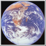 Africa
The crew of Apollo 17 took this photograph of Earth in December 1972 while
the spacecraft was traveling between the Earth and the Moon. The orange-red
deserts of Africa and Saudi Arabia stand in stark contrast to the deep blue
of the oceans and the white of both clouds and snow-covered Antarctica.
(Courtesy NASA/JPL)
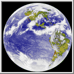 Colored Infrared Earth Image
This infrared image of the Earth was taken by the GOES 6 satellite on
September 21, 1986. A temperature threshold was used to isolate the clouds.
The land and sea were separated and then the clouds, land and sea
were separately colored and combined back together to produce this image.
(Courtesy Rick Kohrs)
A similar 900x900 pixel GIF image showing the African continent can be
found HERE.
(Courtesy Rick Kohrs)
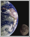
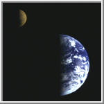 Earth & Moon
Eight days after its encounter with the Earth, the Galileo
spacecraft was able to look back and capture this view of the
Moon in orbit about the Earth, taken from a distance of about 6.2
million kilometers (3.9 million miles), on December 16, 1990.
The Moon is in the foreground,
moving from left to right. The brightly colored Earth contrasts
strongly with the Moon, which reflects only about one third as
much sunlight as the Earth. Contrast and color have been computer
enhanced for both objects to improve visibility. Antarctica is
visible through the clouds (bottom). The Moon's far side is seen;
the shadowy indentation in the dawn terminator is the south
Pole/Aitken Basin, one of the largest and oldest lunar impact
features. (Courtesy NASA/JPL)
 Mariner 10's View of the Earth & Moon
The Earth and Moon were imaged by Mariner 10
from 2.6 million kilometers while completing the first ever Earth-Moon
encounter by a spacecraft capable of returning high resolution digital
color image data. These images have been combined below to illustrate
the relative sizes of the two bodies. From this particular viewpoint
the Earth appears to be a water planet!
(Courtesy USGS/NASA)
 The Earth & Moon
During its flight, the Galileo spacecraft returned
images of the Earth and Moon. Separate images of the Earth and Moon were
combined to generate this view. The Galileo spacecraft took the images in
1992 on its way to explore the Jupiter system in 1995-97. The image shows
a partial view of the Earth centered on the Pacific Ocean about latitude
20 degrees south. The west coast of South America can be observed as well
as the Caribbean; swirling white cloud patterns indicate storms in the
southeast Pacific. The distinct bright ray crater at the bottom of the
Moon is the Tycho impact basin. The lunar dark areas are lava rock filled
impact basins. This picture contains same scale and relative color/albedo
images of the Earth and Moon.
(Courtesy JPL/NASA)
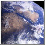 Northeast Africa and the Arabian Peninsula
This image of northeast Africa and the Arabian
Peninsula was taken from an altitude of about 500,000 kilometers (300,000
miles) by the Galileo spacecraft on December 9, 1992, as it left Earth en
route to Jupiter. Visible are most of Egypt (left of center), including
the Nile Valley; the Red Sea (slightly above center); Israel; Jordan, and
the Arabian Peninsula. In the center, below the coastal cloud, is
Khartoum, at the confluence of the Blue Nile and the White Nile. Somalia
(lower right) is partly covered by clouds.
(Courtesy NASA/JPL)
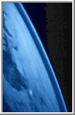
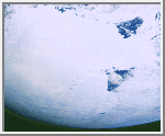 Antarctica
This image of Antarctica was taken by Galileo several hours
after it flew close to the Earth
on December 8, 1990. This is the first picture of the whole Antarctic
continent taken nearly at once from space.
Galileo was about 200,000 kilometers (125,000
miles) from Earth when the pictures were taken.
The icy continent is surrounded by the dark blue of three
oceans: the Pacific to the right, the Indian to the top, and a piece of the
Atlantic to the lower left. Nearly the entire continent was sunlit at
this time of year, just two weeks before southern summer solstice. The
arc of dark spots extending from near the South Pole (close to the center)
toward the upper right is the Transantarctic Mountain Range. To the
right of the mountains is the vast Ross Ice Shelf and the shelf's sharp
border with the dark waters of the Ross Sea. The thin blue line along the
Earth's limb
marks our planet's atmosphere. (Courtesy Calvin J. Hamilton)
 Clementine Mission
This false-colored image was acquired during the Clementine mission.
It shows airglow of the upper atmosphere as a thin blue line. The
bright spot toward the bottom is an urban area.
(Courtesy Naval Research Laboratory)
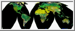 Map projected image of Earth (AVHRR)
This image is a Homolosine projection of the Earth prepared from
Advanced Very High Resolution Radiometer (AVHRR) image data.
(Courtesy ESA/NASA/NOAA/USGS/CSIRO)
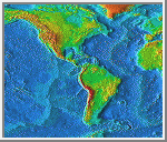 America
This map of North and South America uses radar altimetry to reflect the
underlying topography of the oceans and continents.
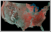 USA
USA
This image is a mosaic of the United States prepared by using 16
images from the Advanced Very High Resolution Radiometer (AVHRR) sensors
on the meteorological satellites NOAA-8 and NOAA-9. The images were
acquired between May 24, 1984 and May 14, 1986.
On false-color infrared mosaics, vegetation appears in various tones
of red instead of green. The "redness" indicates vegetation density,
type and whether growing on dry land or in a swamp (a mixture of reddish
vegetation and dark blue surface water produces dark tones). Grasslands
appear light red, deciduous trees and croplands appear red, and
coniferous forests appear dark red or maroon. Desert areas appear white
and urban areas (pavement and buildings) appear bluish green. Lakes,
rivers and oceans appear in various shades of blue, dark blue for deep
water and light blue for shallow or turbid water. Exposed bedrock
generally appears as a dark bluish-green or other dark tone.
(Courtesy USGS)

 Return to Venus
 Voyage to Mars
