Where there is no vision, the people perish.
- Proverbs 29:18
Table of Contents
|
Additional Mars Resources
|
| Introduction |
|---|
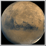
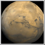
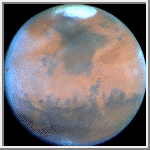
Mars is the fourth planet from the Sun and is commonly referred to as the Red Planet. The rocks, soil and sky have a red or pink hue. The distinct red color was observed by stargazers throughout history. It was given its name by the Romans in honor of their god of war. Other civilizations have had similar names. The ancient Egyptians named the planet Her Descher meaning the red one.
Before space exploration, Mars was considered the best candidate for harboring extraterrestrial life. Astronomers thought they saw straight lines crisscrossing its surface. This led to the popular belief that irrigation canals on the planet had been constructed by intelligent beings. In 1938, when Orson Welles broadcasted a radio drama based on the science fiction classic War of the Worlds by H.G. Wells, enough people believed in the tale of invading Martians to cause a near panic.
Another reason for scientists to expect life on Mars had to do with the apparent seasonal color changes on the planet's surface. This phenomenon led to speculation that conditions might support a bloom of Martian vegetation during the warmer months and cause plant life to become dormant during colder periods.
In July of 1965, Mariner 4, transmitted 22 close-up pictures of Mars. All that was revealed was a surface containing many craters and naturally occurring channels but no evidence of artificial canals or flowing water. Finally, in July and September 1976, Viking Landers 1 and 2 touched down on the surface of Mars. The three biology experiments aboard the landers discovered unexpected and enigmatic chemical activity in the Martian soil, but provided no clear evidence for the presence of living microorganisms in the soil near the landing sites. According to mission biologists, Mars is self-sterilizing. They believe the combination of solar ultraviolet radiation that saturates the surface, the extreme dryness of the soil and the oxidizing nature of the soil chemistry prevent the formation of living organisms in the Martian soil. The question of life on Mars at some time in the distant past remains open.
Other instruments found no sign of organic chemistry at either landing site, but they did provide a precise and definitive analysis of the composition of the Martian atmosphere and found previously undetected trace elements.
The atmosphere of Mars is quite different from that of Earth. It is composed primarily of carbon dioxide with small amounts of other gases. The six most common components of the atmosphere are:
Martian air contains only about 1/1,000 as much water as our air, but even this small amount can condense out, forming clouds that ride high in the atmosphere or swirl around the slopes of towering volcanoes. Local patches of early morning fog can form in valleys. At the Viking Lander 2 site, a thin layer of water frost covered the ground each winter.
There is evidence that in the past a denser martian atmosphere may have allowed water to flow on the planet. Physical features closely resembling shorelines, gorges, riverbeds and islands suggest that great rivers once marked the planet.
The average recorded temperature on Mars is -63° C (-81° F) with a maximum temperature of 20° C (68° F) and a minimum of -140° C (-220° F).
Barometric pressure varies at each landing site on a semiannual basis. Carbon dioxide, the major constituent of the atmosphere, freezes out to form an immense polar cap, alternately at each pole. The carbon dioxide forms a great cover of snow and then evaporates again with the coming of spring in each hemisphere. When the southern cap was largest, the mean daily pressure observed by Viking Lander 1 was as low as 6.8 millibars; at other times of the year it was as high as 9.0 millibars. The pressures at the Viking Lander 2 site were 7.3 and 10.8 millibars. In comparison, the average pressure of the Earth is 1000 millibars.
| Virtual Reality Models of Mars |
|---|
| Animations of Mars |
|---|
| Views of Mars |
|---|
 Sinusoidal Map of Mars
This image is a sinusoidal map of Mars. It was generated from
a digitized airbrush map and was color-coded to represent elevation.
(Credit: Calvin J. Hamilton)
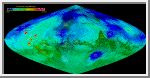
 Martian Topography
This image is a simple cylindrical map of Mars. The color represents
elevation and ranges from -4 kilometers to 27 kilometers.
A Black & White version of this
image is also available.
(Courtesy A.Tayfun Oner)
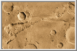
Schiparelli Hemisphere
This image is a mosaic of the Schiparelli hemisphere of
Mars. The center of this image is near
the impact crater Schiparelli, 450 kilometers
(280 miles) in diameter.
The dark streaks with bright margins emanating from craters in
the Oxie Palus region, upper left of image, are caused by erosion
and/or deposition by the wind. Bright white areas to the south,
including the Hellas impact basin at extreme lower right, are
covered by carbon dioxide frost. (Courtesy USGS)
 Valles Marineris
This image is a mosaic of the Valles Marineris [VAL-less mar-uh-NAIR-iss]
hemisphere of Mars. It is a view similar to that which one would see
from a spacecraft. The center of the scene shows the entire Valles
Marineris canyon system, more than 3,000 kilometers (1,860 miles) long
and up to 8 kilometers (5 miles) deep, extending from Noctis
Labyrinthus, the arcuate system of graben to the west, to the chaotic
terrain to the east. Many huge ancient river channels begin from the
chaotic terrain and north-central canyons and run north. Many of the
channels flowed into a basin called Acidalia Planitia, which is the dark
area in the extreme north of this picture. The three Tharsis volcanoes
(dark red spots), each about 25 kilometers (16 miles) high, are visible
to the west. Very ancient terrain covered by many impact craters lies to
the south of Valles Marineris.
(Courtesy USGS)
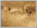
 Central Candor Chasm - Oblique View
This image shows part of Candor Chasm in Valles Marineris.
It is centered at Latitude -5.0, Longitude 70.0. The view
is from the north looking into the chasm. Candor Chasm's geomorphology
is complex, shaped by tectonics, mass wasting, wind, and perhaps by
water and volcanism.
(Courtesy USGS)
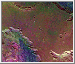 West Candor Chasm (Enhanced Color)
This picture (centered at latitude 4° S, longitude 76° W) shows areas of
central Valles Marineris, including Candor Chasm (lower left), Ophir Chasm
(lower right), and Hebes Chasm (upper right). Complex layered deposits in the
canyons may have been deposited in lakes, and if so, are of great interest for
future searches for fossil life on Mars. The pinkish deposits in Candor Chasm
may be due to hydrothermal alterations and the production of crystalline ferric
oxides. ((Geissler et al., 1993, Icarus 106,380). Viking Orbiter Picture
Numbers 279B02 (violet), 279B10 (green), and 279B12 (red) at 240 meters/pixel
resolution. Picture width is 231 kilometers. North is 47° clockwise from
top.)
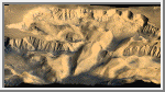
 Landslide in Valles Marineris
Although Valles Marineris originated as a tectonic structure, it has
been modified by other processes. This image shows a close-up view of
a landslide on the south wall of Valles Marineris. This landslide
partially removed the rim of the crater that is on the plateau adjacent
to Valles Marineris. Note the texture of the landslide deposit where it
flowed across the floor of Valles Marineris. Several distinct layers
can be seen in the walls of the trough. These layers may be regions of
distinct chemical composition or mechanical properties in the Martian
crust.
(Image Credit: Calvin J. Hamilton; Caption: LPI)
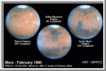 HST 3 Views of Mars at Opposition
These Hubble Space Telescope views provide the most detailed complete
global coverage of the Red Planet ever seen from Earth. The pictures
were taken on February 25, 1995, when Mars was at a distance of 103
million kilometers (65 million miles). To the surprise of researchers,
Mars is cloudier than seen in previous years. This means the planet is
cooler and drier, because water vapor in the atmosphere freezes out to
form ice-crystal clouds. The three images show the Tharsis, Valles
Marineris and Syrtis Major regions.
(Credit: Philip James, University of Toledo; Steven Lee, University
of Colorado; and NASA)
 Springtime on Mars: Hubble's Best View of the Red Planet
This NASA Hubble Space Telescope view of Mars is the
clearest picture ever taken from Earth, surpassed only by close-up
shots sent back by visiting space probes. The picture was taken on
February 25, 1995, when Mars was at a distance of approximately
103 million kilometers (65 million miles) from Earth.
Because it is spring in Mars' northern hemisphere, much of the carbon
dioxide frost around the permanent water-ice cap has sublimated, and
the cap has receded to its core of solid water-ice several hundred
miles across. The abundance of wispy white clouds indicates that the
atmosphere is cooler than seen by visiting space probes in the 1970s.
Morning clouds appear along the planet's western (left) limb. These
form overnight when Martian temperatures plunge and water in the
atmosphere freezes out to form ice-crystal clouds. Towering 25
kilometers (16 miles) above the surrounding plains, volcano
Ascraeus Mons pokes above the cloud deck near the western or limb.
Valles Marineris is in the lower left.
(Credit: Philip James, University of Toledo; Steven Lee, University
of Colorado; and NASA)
 Outflow Source of Channel Ravi Vallis
This image of the head of Ravi Vallis shows a 300-kilometer (186-mile)
long portion of a channel. Like many other channels that empty into
the northern plains of Mars, Ravi Vallis orginates in a region of
collapsed and disrupted ("chaotic") terrain within the planet's older,
cratered highlands. Structures in these channels indicate that they
were carved by liquid water moving at high flow rates. The abrupt
beginning of the channel, with no apparent tributaries, suggests that
the water was released under great pressure from beneath a confining
layer of frozen ground. As this water was released and flowed away, the
overlying surface collapsed, producing the disruption and subsidence
shown here. Three such regions of chaotic collapsed material are seen in
this image, connected by a channel whose floor was scoured by the flowing
water. The flow in this channel was from west to east (left to right).
This channel ultimately links up with a system of channels that flowed
northward into Chryse Basin.
(Image Credit: Calvin J. Hamilton; Caption: LPI)
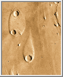 Streamlined Islands
The water that carved the channels to the north and east of the Valles
Marineris canyon system had tremendous erosive power. One consequence
of this erosion was the formation of streamlined islands where the water
encountered obstacles along its path. This image shows two streamlined
islands that formed as the water was diverted by two 8-10 kilometer
(5-6 mile) diameter craters lying near the mouth of Ares Vallis in Chryse
Planitia. The water flowed from south to north (bottom to top of the
image). The height of the scarp surrounding the upper island is about 400
meters (1,300 feet), while the scarp surrounding the southern island is
about 600 meters (2,000 feet) high.
(Image Credit: Calvin J. Hamilton; Caption: LPI)
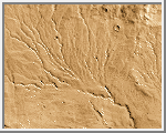 Valley Network
Unlike the features shown in the above two images, many systems on Mars
do not show evidence of catastrophic flooding. Instead, they show a
resemblance to drainage systems on Earth, where water acts at
slow rates over long periods of time. As on Earth, the channels shown
here merge together to form larger channels.
However, these valley networks are less developed than typical terrestrial
drainage systems, with the Martian examples lacking small-scale streams
feeding into the larger valleys. Because of the absence of small-scale
streams in the Martian valley networks, it is thought that the valleys
were carved primarily by ground water flow rather than by runoff of
rain. Although liquid water is currently unstable on the surface of
Mars, theoretical studies indicate that flowing groundwater might be
able to form valley networks if the water flowed beneath a protective
cover of ice. Alternatively, because the valley networks are confined
to relatively old regions of Mars, their presence may indicate that Mars
once possessed a warmer and wetter climate in its early history.
(Image Credit: Calvin J. Hamilton; Caption: LPI)
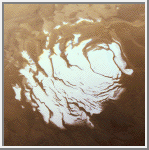 South Polar Cap
This image shows the south polar cap of Mars as it appears near
its minimum size of about 400 kilometers (249 miles). It consists
mainly of frozen carbon dioxide. This carbon dioxide cap never melts
completely. The ice appears reddish due to dust that has been
incorporated into the cap. (Courtesy NASA)
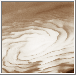 North Polar Cap
This image is an oblique view of the north polar cap of Mars.
Unlike the south polar cap, the north polar cap probably consists
of water-ice.
(Courtesy Calvin J. Hamilton)
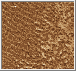 Dunefield
This image shows several dune types which are found in the north
circumpolar dunefield. This thumnail image shows a section of transverse
dunes. The full image has a field of traverse dunes on the left and
barchan dunes on the right with a transition zone inbetween. Transverse
dunes are oriented perpendicular to the prevailing wind direction. They
are long and linear, and frequently join their neighbor in a low-angle
"Y" junction. Barchan dunes are crescent-shaped mounds with
downwind-pointing horns. These dunes are comparable in size to the
largest dunes found on the Earth.
(Courtesy Calvin J. Hamilton)
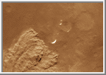 Local Dust Storm
Local dust storms are relatively common on Mars. They tend to occur in
areas of high topographic and/or high thermal gradients (usually near the
polar caps), where surface winds would be strongest. This storm is
several hundreds of kilometers in extent and is located near the edge
of the south polar cap. Some local storms grow larger, others die out.
(Courtesy Calvin J. Hamilton, and LPI)
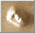 Face on Mars
This image shows the Face on Mars that imaginative writers
have cited as evidence for intelligent life on Mars. It is more
likely that this hill, in the northern plains, has been eroded by
the wind to give it a face like appearance.
(Courtesy Calvin J. Hamilton)
For an detailed discussion of the face on Mars, click
HERE.
| Mars Moon Summary |
|---|
The following table summarizes the radius, mass, distance from the planet center, discoverer and the date of discovery of each of the moons of Mars:
| Moon | # | Radius (km) | Mass (kg) | Distance (km) | Discoverer | Date |
|---|---|---|---|---|---|---|
| Phobos | I | 13.5x10.8x9.4 | 1.08e+16 | 9,380 | A. Hall | 1877 |
| Deimos | II | 7.5x6.1x5.5 | 1.80e+15 | 23,460 | A. Hall | 1877 |
| References |
|---|
Beatty, J. K. and A. Chaikin, eds. The New Solar System. Massachusetts: Sky Publishing, 3rd Edition, 1990.
Carr M. H. The Surface of Mars. Yale University Press, New Haven, 1981.
Kiefer, Walter S., Allan H. Treiman, and Stephen M. Clifford. The Red Planet: A Survey of Mars - Slide Set. Lunar and Planetary Institute.
Mutch T. A., Arvidson R. E., Head J. W. III, Jones K. L., and Saunders R. S. The Geology of Mars. Princeton University Press, Princeton, 1976.
Williams, Steven H. The Winds of Mars: Aeolian Activity and Landforms - Slide Set. Lunar and Planetary Institute.

 Return to Earth
 Voyage to Jupiter
