
Freedom lies in being bold. - Robert Frost
Europa [yur-ROH-pah] is a strange looking moon of Jupiter with a large number of intersecting features. It is unlike Callisto and Ganymede with their heavily cratered crusts. Europa has almost a complete absence of craters as well as almost no vertical relief. As one scientist put it, the features "might have been painted on with a felt marker". There is a possibility that Europa may be internally active due to tidal heating at a level one-tenth or less that of Io. Models of Europa's interior show that beneath a thin 5 km (3 miles) crust of water ice, Europa may have oceans as deep as 50 km (30 miles) or more. The visible markings on Europa could be a result of global expansion where the crust could have fractured, filled with water and froze.
| Views of Europa |
|---|
See also: Additional Galileo Images of Europa.
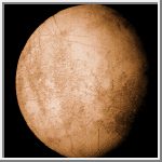
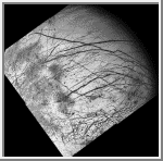
Europa
This is one of the highest resolution images of Europa obtained by
Voyager 2.
It shows the smoothness of most of the terrain and the near absence
of impact craters. Only three craters larger than 5 km in diameter have
been found.
(Credit: Calvin J. Hamilton)
 Europa From a Distance
This view of Europa was taken by Voyager 2 and shows a bright,
low-contrast surface with a network of lines which crisscross much
of its surface.
(Credit: Calvin J. Hamilton)
 Galileo Mercator Mosaic of Europa
This image is a mosaic of Europa based of Galileo G1 and G2 images. The USGS
controlled global mosaic was used for reference. This map is a mercator
projection with the central longitude at 180° and the latitude covers
-70° to 70°.
(Courtesy A.Tayfun Oner)
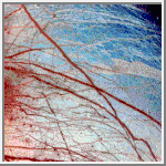
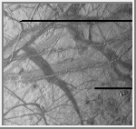 Ridges on Europa
This view of Europa shows a portion of the surface that
has been highly disrupted by fractures and ridges. This picture covers
an area about 238 kilometers (150 miles) wide by 225 kilometers (140
miles), or about the distance between Los Angeles and San Diego.
Symmetric ridges in the dark bands suggest that the surface crust was
separated and filled with darker material, somewhat analogous to
spreading centers in the ocean basins of Earth. Although some impact
craters are visible, their general absence indicates a youthful
surface. The youngest ridges, such as the two features that cross the
center of the picture, have central fractures, aligned knobs, and
irregular dark patches. These and other features could indicate
cryovolcanism, or processes related to eruption of ice and gases.
This picture, centered at 16 degrees south latitude, 196 degrees west
longitude, was taken at a distance of 40,973 kilometers (25,290 miles) on
November 6, 1996 by the solid state imaging television camera
onboard the Galileo spacecraft
during its third orbit around Jupiter.
(Courtesy: NASA/JPL)
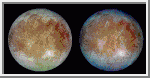 Natural and False Color Views of Europa
This image shows two views of the trailing hemisphere
of Europa. The left image shows the
approximate natural color appearance of Europa. The image on the right is
a false-color composite version combining violet, green and infrared
images to enhance color differences in the predominantly water-ice crust
of Europa. Dark brown areas represent rocky material derived from the
interior, implanted by impact, or from a combination of interior and
exterior sources. Bright plains in the polar areas (top and bottom) are
shown in tones of blue to distinguish possibly coarse-grained ice (dark
blue) from fine-grained ice (light blue). Long, dark lines are fractures
in the crust, some of which are more than 3,000 kilometers (1,850 miles)
long. The bright feature containing a central dark spot in the lower third
of the image is a young impact crater some 50 kilometers (31 miles) in
diameter. This crater has been provisionally named 'Pwyll' for the Celtic
god of the underworld.
(Courtesy: NASA/JPL)
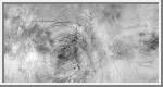
 False Color Image of Minos Linea Region
False color has been used here to enhance the
visibility of certain features in this composite of three images of the
Minos Linea region on Jupiter's moon Europa taken on 28 June 1996
Universal Time by the Galileo
spacecraft. Triple bands, lineae and mottled terrains appear in brown and
reddish hues, indicating the presence of contaminants in the ice. The icy
plains, shown here in bluish hues, subdivide into units with different
albedos at infrared wavelengths probably because of differences in the
grain size of the ice. The composite was produced using images with
effective wavelengths at 989, 757, and 559 nanometers. The spatial
resolution in the individual images ranges from 1.6 to 3.3 kilometers (1
to 2 miles) per pixel. The area covered, centered at 45N, 221 W, is about
1,260 km (about 780 miles) across.
(Courtesy: NASA/JPL)
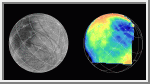 Galileo Near-Infrared Image of Europa
The Near Infrared Mapping Spectrometer (NIMS) on the
Galileo spacecraft imaged most of Europa, including the north polar
regions, at high spectral resolution at a range of 156,000 km (97,500
miles) during the G1 encounter on June 28 1996. The image on the right
shows Europa as seen by NIMS, centered on 25 degrees N latitude, 220 W
longitude. This is the hemisphere that always faces away from Jupiter. The
image on the left shows the same view point from the Voyager data (from
the encounters in 1979 and 1980). The NIMS image is in the 1.5 micron
water band, in the infrared part of the spectrum. Comparison of the two
images, infrared to visible, shows a marked brightness contrast in the
NIMS 1.5 micron water band from area to area on the surface of Europa,
demonstrating the sensitivity of NIMS to compositional changes. NIMS
spectra show surface compositions ranging from pure water ice to mixtures
of water and other minerals which appear bright in the infrared.
 Europa's Broken Ice
Jupiter's moon Europa, as seen in this image taken June 27, 1996 by NASA's
Galileo spacecraft, displays features in some areas resembling ice floes seen in
Earth's polar seas. Europa has an icy crust
that has been severely fractured, as indicated by the dark linear, curved, and
wedged-shaped bands seen here. These fractures have broken the crust into
plates as large as 30 kilometers (18.5 miles) across. Areas between the plates
are filled with material that was probably icy slush contaminated with rocky
debris. Some individual plates were separated and rotated into new positions.
Europa's density indicates that it has a shell of water ice as thick as 100
kilometers (about 60 miles), parts of which could be liquid. Currently, water
ice could extend from the surface down to the rocky interior, but the features
seen in this image suggest that motion of the disrupted icy plates was
lubricated by soft ice or liquid water below the surface at the time of
disruption.
This image covers part of the equatorial zone of Europa and was taken from a
distance of 156,000 kilometers (about 96,300 miles) by the solid-state imager
camera on the Galileo spacecraft. North is to the right and the sun is nearly
directly overhead. The area shown is about 360 by 770 kilometers (220-by-475
miles or about the size of Nebraska), and the smallest visible feature is about
1.6 kilometers (1 mile) across.
(Courtesy: NASA/JPL)
 Europa's Active Surface
A newly discovered impact crater can be seen just right of the center of this
image of Jupiter's moon Europa returned by NASA's Galileo spacecraft camera.
The crater is about 30 kilometers (18.5 miles) in diameter. The impact
excavated into Europa's icy crust, throwing debris (seen as whitish material)
across the surrounding terrain. Also visible is a dark band, named Belus Linea,
extending east-west across the image. This type of feature, which scientists
call a "triple band," is characterized by a bright stripe down the middle.
The outer margins of this and other triple bands are diffuse, suggesting that the
dark material was put there as a result of possible geyser-like activity which shot
gas and rocky debris from Europa's interior. The curving "X" pattern seen in the
lower left corner of the image appears to represent fracturing of the icy crust
and infilling by slush which froze in place.
The crater is centered at about 2 degrees north latitude by 239 degrees west
longitude. The image was taken from a distance of 156,000 kilometers (about
96,300 miles) on June 27, 1996, during Galileo's first orbit around Jupiter.
The area shown is 860 by 700 kilometers (530 by 430 miles), or about the size
of Oregon and Washington combined.
(Courtesy: NASA/JPL)
 Dark Bands on Europa
Dark crisscrossing bands on Jupiter's moon Europa represent widespread
disruption from fracturing and the possible eruption of gases and rocky
material from the moon's interior in this four-frame mosaic of images
from NASA's Galileo spacecraft. These and other features suggest that
soft ice or liquid water was present below the ice crust at the time of
disruption. The data do not rule out the possibility that such
conditions exist on Europa today. The pictures were taken from a
distance of 156,000 kilometers (about 96,300 miles) on June 27, 1996.
Many of the dark bands are more than 1,600 kilometers (1,000 miles)
long, exceeding the length of the San Andreas fault of California.
Some of the features seen on the mosaic resulted from meteoritic
impact, including a 30-kilometer (18.5 mile) diameter crater visible as
a bright scar in the lower third of the picture. In addition, dozens
of shallow craters seen in some terrains along the sunset terminator
zone (upper right shadowed area of the image) are probably impact
craters. Other areas along the terminator lack craters, indicating
relatively youthful surfaces, suggestive of recent eruptions of icy
slush from the interior. The lower quarter of the mosaic includes
highly fractured terrain where the icy crust has been broken into slabs
as large as 30 kilometers (18.5 miles) across.
The mosaic covers a large part of the northern hemisphere and includes
the north pole at the top of the image. The sun illuminates the
surface from the left. The area shown is centered on 20 degrees north
latitude and 220 degrees west longitude and is about as wide as the
United States west of the Mississippi River.
(Courtesy: NASA/JPL)
Copyright © 1997 by Calvin J. Hamilton. All rights reserved.