One might have thought that Nature lived hard
by and was brewing on
a large scale.
-Dickens
Miranda [mih-RAN-dah] is not one of the larger satellites of Uranus; however, it was the one that was approached the closest by Voyager 2. This was not the satellite scientists would have chosen to get close to if they had a choice, but they had no choice. Voyager 2 had to fly close to the planet in order to get the boost it needed to go to Neptune. The resolution at which the larger satellites were photographed was around 2 to 3 kilometers (1.2 to 1.9 miles). On the other hand, details on the order of a few hundred meters can be seen on Miranda. Fortunately, Miranda turned out to be the most remarkable of all the satellites.
Miranda is a small satellite with a diameter of 470 kilometers (290 miles). Its surface is unlike anything in the solar system with features that are jumbled together in a haphazard fashion. Miranda consists of huge fault canyons as deep as 20 kilometers (12 miles), terraced layers and a mixture of old and young surfaces. The younger regions might have been produced by incomplete differentiation of the moon, a process in which upwelling of lighter material surfaced in limited areas. Alternatively, scientists believe that Miranda may have been shattered as many as five times during its evolution. After each shattering the moon would have reassembled from the remains of its former self with portions of the core exposed and portions of the surface buried. Miranda's appearence can be explained by theories, but the real reason is still unknown.
Given Miranda's small size and low temperature (-187° C or -335° F), the degree and diversity of the tectonic activity on this moon has surprised scientists. It is believed that an additional heat source such as tidal heating caused by the gravitational tug of Uranus must have been involved. In addition, some means must have mobilized the flow of icy material at low temperatures.
Miranda was named after the daughter of the magician Prospero in Shakespeare's play The Tempest.
| Animation of Miranda |
|---|
| Views of Miranda |
|---|
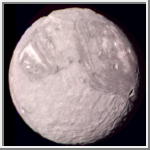
Miranda - Color Picture
This color composite of the Uranian satellite Miranda was taken by Voyager 2 on
January 24, 1986, from a distance of 147,000 kilometers (91,000 miles).
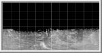
Miranda's regional geologic provinces
show very well in this view of the southern hemisphere, imaged at a resolution
of 2.7 kilometers (1.7 miles). The dark- and bright-banded region with its
curvilinear traces covers about half of the image. Higher-resolution pictures
taken later show many fault valleys and ridges parallel to these bands. Near
the terminator (at right), another system of ridges and valleys abuts the banded
terrain; many impact craters pockmark the surface in this region. The largest of
these are about 30 kilometers (20 miles) in diameter; many more lie in the range
of 5 to 10 kilometers (3 to 6 miles) in diameter.
(Courtesy NASA/JPL)
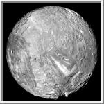 Orthographic Image of Miranda
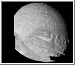
This image is an orthographic image of Miranda centered at the south pole.
Zero degrees logitude, which is the central longitude of the side facing Uranus,
is at the bottom. The image was computer-assembled from images obtained January
24, 1986, by the Voyager 2 spacecraft.
Miranda is the innermost and smallest of the five major Uranian
satellites, just 480 kilometers (about 300 miles) in diameter.
This image is a full-disc, south-polar
view of the moon showing the varying geologic provinces of Miranda.
The moon's surface consists of two major strikingly different
types of terrain. One is an old, heavily cratered, rolling
terrain with relatively uniform albedo,
or reflectivity. The
other is a young, complex terrain characterized by sets of bright
and dark bands, scarps
and ridges. These are features found in the
ovoid
regions at right and left and in the distinctive chevron
feature below and right of center.
(Courtesy A. Tayfun Oner)
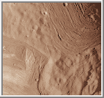 The Chevron
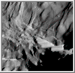
This view of Miranda shows details as small as
600 meters
across. It was acquired by Voyager 2 on January 24, 1986.
This is a close-up view of the chevron which shows the light and
dark grooves with its sharp boundaries. The upper right shows a region
of uniformly dark grooved terrain. The area shown is about
150 kilometers (93 miles) on a side.
(Credit: Calvin J. Hamilton)
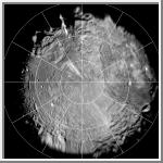 Polar Stereographic Map of Miranda
This image is a polar stereographic map of the southern hemisphere of
Miranda. Zero degrees longitude is at the top.
(Courtesy A. Tayfun Oner)
 Cylindrical Map of Miranda
This image is a simple cylindrical map projection of Miranda. Zero degrees
longitude is at the center and 1 pixel equals 1 kilometer at the equator.
(Courtesy A. Tayfun Oner)
 High Resolution Mosaic
This computer-assembled mosaic of Miranda includes
many of the high-resolution frames obtained by Voyager 2 during its close
flyby of the Uranian moon. Miranda, roughly 500 kilometers (300 miles) in
diameter, exhibits varied geologic provinces, seen in this mosaic of
clear-filter, narrow-angle images from January 24, 1986. The images were
obtained from distances of 30,160 to 40,310 kilometers (18,730 to 25,030 miles);
resolution ranges from 560 to 740 meters (1,840 to 2,430 feet). These are
among the highest-resolution pictures that Voyager has obtained of any of
the new 'worlds' it has encountered during its mission. On Miranda, ridges
and valleys of one province are cut off against the boundary of the next
province. Probable compressional (pushed-together) folded ridges are seen
in curvilinear patterns, as are many extensional (pulled-apart) faults.
Some of these show very large scarps, or cliffs, ranging from 0.5 to 5 kilometers
(0.3 to 3 miles) in height -- that is, higher that the walls of the Grand
Canyon on Earth.
(Courtesy NASA/JPL)
 High Resolution of Large Fault
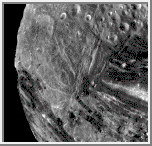
This high-resolution image of Miranda was acquired by
Voyager 2 on January 24, 1986, when the spacecraft was 36,250 kilometers
(22,500 miles) from the Uranian moon. In this clear-filter, narrow-angle
image, Miranda displays a dramatically varied surface. Well shown at this
resolution of 660 meters (2,160 feet) are numerous ridges and valleys -- a
topography that was probably produced by compressional tectonics. Cutting
across the ridges and valleys are many faults. The largest fault scarp, or
cliff, is seen below and right of center; it shows grooves probably made
by the contact of the fault blocks as they rubbed against each other
(leaving what are known as slickensides). Movement of the down-dropped
block is shown by the offset of the ridges. The fault may be 5 kilometers (3 miles)
high, or higher than the walls of the Grand Canyon on Earth.
(Courtesy NASA/JPL)
 Fractures, Grooves and Craters
This Voyager 2 image of Miranda was taken January 24,
l986, from a distance of about 31,000 kilometers (19,000 miles), shortly
before the spacecraft's closest approach to the Uranian moon. The high
resolution of 600 meters (2,000 feet) reveals a bewildering variety of
fractures, grooves and craters, as well as features of different
albedos.
This clear-filter, narrow-angle view encompasses areas of
older, heavily cratered terrain with a wide variety of forms. The grooves
and troughs reach depths of a few kilometers (or miles) and expose
materials of different albedos. The great variety of directions of
fracture sand troughs, and the different densities of impact craters on
them, signify a long, complex geologic evolution of this satellite.
(Courtesy NASA/JPL)

 Uranus
 Puck
Puck Ariel
Ariel