Ariel [AIR-ee-al] is a relatively small satellite and is the brightest moon of Uranus. The surface is pock-marked with craters, but the most outstanding features are long rift valleys stretching across the entire surface. Canyons much like the ones on Mars appear in the pictures. The canyon floors appear as though they have been smoothed by a fluid. The fluid could not have been water because water acts like steel at these temperatures. The flow marks might have been made by ammonia, methane or even carbon monoxide.
| Views of Ariel |
|---|
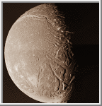
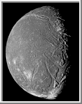
Ariel
This image of Ariel shows a world pock-marked with craters. Across its
surface long rift valleys extend.
Ariel has canyons similar
to those on Mars, with canyon floors that appear
to have been smoothed by a fluid. The fluid could not have been water
because water acts like steel at these temperatures. The
flow marks might have been made by ammonia, methane or even carbon
monoxide.
(Credit Calvin J. Hamilton)
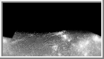 Mercator Map of Ariel
This image is a mercator map of Ariel.
The map covers from 70 to -70 degrees latitude with 0 degree longitude
located at the center. The scale is 2km/pixel at the equator.
(Courtesy A. Tayfun Oner)
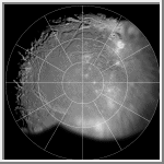 Polar Stereographic Map of Ariel
This image is a polar stereographic map of the southern hemisphere of
Ariel. Zero degrees longitude is at the top. The best
unsmeared Voyager 2 images of Ariel were used in making this map.
(Courtesy A. Tayfun Oner)
 Orthographic View of Ariel
This image is an orthographic view of Ariel centered at -66 degrees latitude
and 316 degrees longitude.
(Courtesy A. Tayfun Oner)
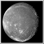
 Highest Resolution Mosaic of Ariel
This image of Ariel is at the same geometry of the highest resolution
mosaic of Ariel taken by Voyager. The mosaic consists of four clear
filter images. Two of these images that covered the terminator were
smeared because of the longer exposure times. The mosaic was made as follows:
First the map of Ariel (which was made by
using the best unsmeared pictures of any region) was projected into the
highest resolution mosaic geometry. Then in order to restore the limb
topography, thin slices were cut from the limbs of the original images
and were mosaicked with the projected image.
(Courtesy A. Tayfun Oner)

 Uranus
 Miranda
 Umbriel