Main research and development work completed in 2012 and ready for implementation
|
| |
The development of satellite-based web-service VEGA for vegetation cover monitoring to support fundamental research of biosphere and applications
Nowadays remote sensing satellite systems provide a continuous stream of environmental data in temporal and spatial resolution ranges. To use efficiently obtained large satellite data bulk it is necessary to develop automated technologies for data collection, storage, pre-processing and thematic analysis, as well as for data products delivery to end-users as input to science and applications. Moreover, scientific research requires technologies for effective analysis of long-term satellite data and derived products time-series.
During the years 2011-2012 IKI has developed satellite-based service VEGA (http://vega.smislab.ru) for informational support of wide range of scientific researches and applications with focus on the Earth vegetation status and dynamics including agricultural lands, forests, tundra and etc. The VEGA service provides an easy-to-use interface and analysis tools for continuously acquired multi-annual time-series of satellite data from open sources, such as e.g. Terra/Aqua-MODIS and Landsat-TM/ETM+. In not distant future the NPP, Landsat-8, Sentinel-2, Konopus-B and Meteo-M data are supposed to be also available through the VEGA service.
The VEGA service provides access to continuously updated time-series of satellite data covering entire Russia and neighboring countries. An automated MODIS data pre-processing technology allows contaminated pixels screening and building of vegetation indexes time-series closely correlated with green biomass volume and status. The vegetation indexes time-series seasonal and inter-annual dynamics made a basis for development of land cover mapping and monitoring techniques, in particularly focused on assessment of crop status, forest burned area assessment and etc. The VEGA service data analysis tools provide the following functional capabilities:
- Comprehensive combine analysis of moderate and high spatial resolution satellite data as well as their processing results along with other spatial information;
- Assessment of vegetation indexes seasonal and multi-annual dynamics in order to characterise land cover changes;
- Delineation and attributing of different land cover objects based on analysis of their status and dynamics;
- Temporal and spatial analysis of the satellite data derived information products;
- Deriving of statistics on vegetation cover conditions in particular areas of interest.
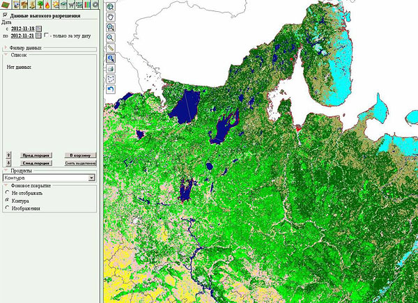
Fig.1 The VEGA service web interface with land cover map of Russia
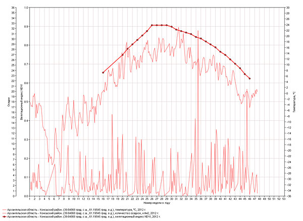
Fig.2 The example of combine analysis of vegetation index seasonal dynamics and meteorological data using of VEGA service tools
Publications
- Loupian E.A., Savin I.Y., Bartalev S.A., Tolpin V.A., Balashov I.V., Plotnikov D.E. Satellite service for monitoring of vegetation cover status (“Vega”) // Contemporary remote sensing of the Earth from Space, 2011. V.8. ą 1. P.190-198.
- Bartalev S.A., Ershov D.V., Loupian E.A., Tolpin V.A. Satellite-based web-service VEGA facilities for various terrestrial ecosystems monitoring applications // Contemporary remote sensing of the Earth from Space, 2012. V. 9. ą 1. P.49-56.
- Bartalev S.A., Egorov V.A., Ershov D.V., Isaev A.S., Loupian E.A., Plotnikov D.E., Uvarov I.A. Mapping of Russia’s vegetation cover using MODIS satellite spectroradiometer data // Contemporary remote sensing of the Earth from Space, 2011. V.8. ą 4. P.285-302.
- Bartalev S.A., Egorov V.A., Efremov V.Y., Loupian E.A., Stytsenko F.V., Flitman E.V. Integrated burnt area assessment based on combine use of multi-resolution MODIS and Landsat-TM/ETM+ satellite data // Contemporary remote sensing of the Earth from Space, 2012. V. 9. ą 2. P.9-27.
- Bartalev S.A., Egorov V.A., Loupian E.A., Plotnikov D.E., Uvarov I.A. Recognition of arable lands using multi-annual satellite data from spectroradiometer MODIS and locally adaptive supervised classification // Computer-based optics. Samara. ISOI RAN, 2011. V.35. ą 1. P.103-116.
Contacts:
- Loupian E.A., DrSc, e-mail: evgeny@smis.iki.rssi.ru
- Bartalev S.A., DrSc, e-mail: bartalev@smis.iki.rssi.ru
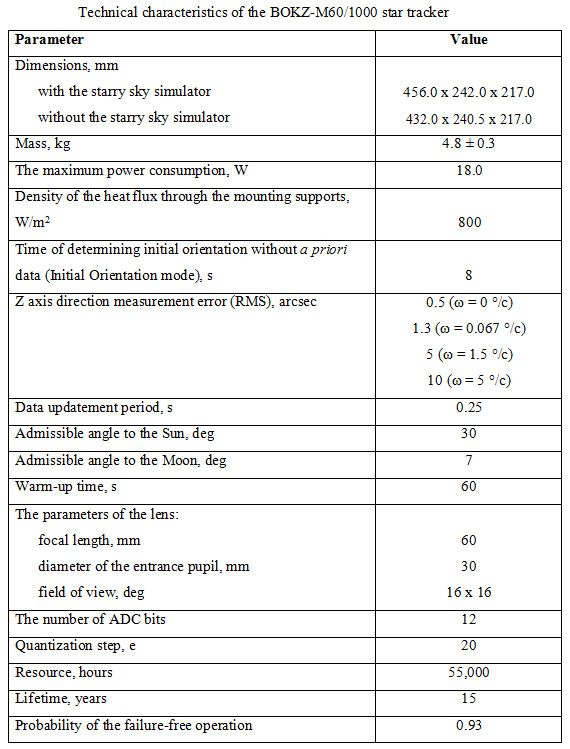
BOKZ-M60/1000 Star Tracker
In 2012 the development of the precision opto-electronic star tracker – BOKZ-M60/1000 – was finalized at IKI RAN. The instrument has been designed for spacecraft attitude control based on images of the arbitrary starry sky segments. BOKZ-M60/1000 is a monoblock, mounted on the external surface of the spacecraft, outside the pressurized compartment. The device consists of:
- a two-stage baffle, providing for imaging the starry sky segment for the sun angle (an angle between the direction to the Sun and the tracker axis direction) equal to 30°,
- the "Astrar-8" lens module,
- a video signal transmission module with the "Sphere-1000" CCD (the number of elements - 1024x1024),
- a processor module, which provides for the tracker operation control and performs the necessary calculations,
- a secondary power supply module, generating voltage necessary for the tracker functioning.
An image of an arbitrary starry sky section formed on the CCD is localized, and then the energy centers of the objects together with the angular distances between the objects are determined. Comparing the angular distances of the star images configuration with the angular distances between the stars from the onboard star catalogue (stored in the processor module memory) the orientation of the BOKZ-M60/1000 coordinate system in the second equatorial coordinate system is determined. The output data has a form of an orientation quaternion tied to the middle of CCD exposure time with an error of 3x10⁻⁵s.
Hardware solutions and specially developed algorithms made it possible to obtain high accuracy of orientation determination within a range of the angular velocities from 0 °/s to 65 °/s as well as to increase the orientation data output frequency up to 4 Hz.
BOKZ-M60/1000 star tracker qualification unit passed the design developmental tests with a positive result, which concluded in assigning qualification to the design documentation. Six BOKZ-M60/1000 flight units have been manufactured and delivered to the Samara Space Center for flight operation.
The performance of the BOKZ-M60/1000 star tracker is similar to foreign counterparts, and in precision parameters even exceeds them. There are no analogs of the BOKZ-M60/1000 star tracker in the Russian Federation.
Designers:
- G.A. Avanesov, Chief Designer
- V.Yu. Belov, the leading designer
- R.V. Bessonov, deputy chief designer
- I.Yu. Katasonov, programmer of the 1st category
- A.A. Krupin, chief expert
- M.I. Kudelin, chief designer of the project
- V.M. Muraviov, the chief designer of the project
- V.S. Troshin, head of the design department
- A.A. Forsch, deputy chief designer
- A. Shpomer
Scientific and technical information:
- BOKZ-M60/1000. Preliminary Design, Vol.1, 2. 2009
- Specifications NRDK.201231.035TU
- Operating manual NRDK.201231.035RE
- Acceptance test instructions NRDK.201231.035IV
Main research and development work completed in 2011 and ready for implementation
Main research and development work completed in 2010 and ready for implementation
Main research and development work completed in 2009 and ready for implementation
Main research and development work completed in 2008 and ready for implementation
|
|